Queenstown Hikes
There is a wealth of walking and hiking opportunities in and around Queenstown. Everything from walks of only a couple hours, to full day hikes and even overnight options. We’ve listed some of our favorites here, but this is by no means an exhaustive list.
Whenever you’re hiking in New Zealand – especially in the mountains – you should go out prepared. Snow in summer is not uncommon during storms, so bring a warm layer even if you’re leaving with blue sunny skies.
Ben Lomond Summit Track

Getting There: This walk leaves directly from Queenstown.
How long? 5 – 7 hours return.
Ben Lomond towers over Queenstown and begs to be summited. It’s an accessible hike on a well formed trail that affords you stunning views of Queenstown, Lake Wakatipu and the greater Wakatipu Basin. A return trip from Queenstown should take no more than about six hours and should only be attempted in times of no snow.
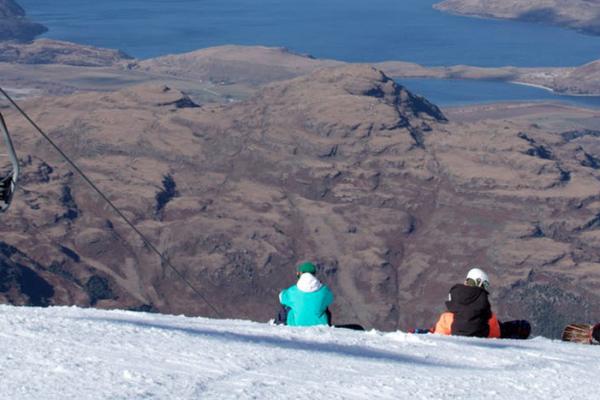
If you don’t have enough time to tackle the summit, you can go as far as Ben Lomond Saddle in about 3 hours return and are greeted with the view above. If you’re keen to take a short cut, hop on the Skyline Gondola going up to knock 45 minutes off the trip time.
Walk up Queenstown Hill

Getting There: This walk leaves directly from Queenstown.
How long? 1 – 3 hours return.
Yet another excellent walk leaving directly from downtown Queenstown, the walk to the top of Queenstown Hill is significantly shorter than the trip of Ben Lomond. You can reach the top in just over an hour with sweeping views out across Lake Wakatipu.
Sawpit Gully Trail

Getting There: This walk leaves directly from Arrowtown.
How long? 2 – 3 hour loop.
This is a lovely loop walk that leaves from Arrowtown. We suggest going in a clockwise direction from Arrowtown – your legs (and lungs!) will get warmed up with a steep walk up a hill that opens to sweeping views across the Wakatipu Basin. From here you’ll follow a water race down Sawpit Gully itself, crossing the creek on a number of occassions and passing beech forest pockets as well as high country tussock covered slopes. Beware of the sharp and prickly matagouri bushes and speargrass patches common in this area of the South Island.
Reward yourself with a pint at the Arrotown Brewery when you finish.
Lake Hayes Loop

Getting There: Lake Hayes is approximately 20 minutes away from Queenstown on the way to Arrowtown.
How long? 1.5 – 2 hour loop.
This is a lovely loop walk that circumnavigates Lake Hayes. It’s a well-graded multi-use trail, so beware of mountain bikers on the track. In the summer, you might wish to have a swim in the lake when you finish as it’s significantly warmer than Lake Wakatipu.
Mt Alfred Summit

Getting There: This walk starts about twenty minutes away from Glenorchy, which is about an hour drive away from Queenstown. Follow signposts to the start of the Routeburn Track and you’ll see the carpark where the track begins about 20 kms from quaint Glenorchy.
How long? 5 – 6 hours return.
This 1,375 metre peak juts out between the Dart and Rees River valleys and simply begs to be climbed. It’s unique to many accessible day-hikes in New Zealand in that it contains a fantastic mix of hiking through the dense bush, with some scrambling near the top along with panoramic views from the summit.
The hike begins from the western side of Mount Alfred in the Dart River valley. The first couple hours takes you steadily up through native beech forest before reaching the tree line. From here, look for the orange pylons marking the route above the bushline. After popping up to the plateaued summit, you can spend time wandering around and taking the views of Lake Wakatipu, the Dart & Rees Valleys, the Humbolts and majestic Mt Earnslaw.
Day Walk on the Routeburn Track

Getting There: This walk starts about thirty minutes away from Glenorchy and signposts lead you to the start of the track.
How long? 1 hour to 7 hours return, depending on how far you want to walk.
The Routeburn Track stretches 32 kilometres through the Mount Aspiring and Fiordland National Parks and along the way passes a huge variety of landscapes. It’s a multi-day Great Walk, but you can tackle small sections of it over the course of a day if you’re short on time. We suggest walking as far as Routeburn Falls Hut (or a little farther) and out in about 5 – 6 hours return.
After walking along the Routeburn Flats and passing the first hut on the track of the same name, you quickly begin to gain elevation. While the track becomes a bit more physically challenging, it’s still not difficult. At about 900 meters you reach a point where a massive slip has totally cleared out the native forest. The slip occurred in 1987 and had the result of opening up this remarkable view of The Humbolts. It’s a great place to drop your pack, grab your lunch and really allows you to appreciate the South Island’s untouched beauty.
Let Us Help You Plan Your Dream New Zealand Trip
Get help creating the perfect self-drive itinerary, finding the best deal on a car or campervan rental or booking the perfect tour. We offer personalized support prior to your trip. Contact us or fill out our FREE Travel Planning Service form below.
